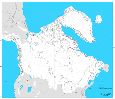
This dataset contains digital, geo-spatial information about the Deglaciation of North America, released as Geological Survey of Canada Open File 1574. The geo-spatial information includes the glacial margins at defined time slices and carbon 14 dated sample locations used to define these glacial margins. In total, 32 time slices are presented ranging from 5000 to 102500 years ago.

Metadata
| Title | Deglaciation of North America |
| Author | Dyke, A. S., A. Moore, and L. Robertson |
| Date | 2003 |
| Coverage | Canada wide |
| Language | English |
| Format |
GIS Data: ESRI Shape [.SHP], ArcInfo [.e00] Image Files: [.BMP] and [.PDF] |
| Projection | Lambert Conformal |
| User Agreement | Geological Survey of Canada is the copyright holder of this product. It is available to McGill University researchers, students, and faculty ONLY for purposes of study, teaching and research. |
| Documentation | User Guide (meta1547.rtf) available on the CD-ROM. |
| Access | Available Online: http://geoscan.nrcan.gc.ca/starweb/geoscan/servlet.starweb?path=geoscan/downloade.web&search1=R=214399 |
| Citation | Dyke, A.S., Moore, A. and L. Robertson. [computer file]. Deglaciation of North America. Geological Survey of Canada Open File 1547. Ottawa: Natural Resources Canada, 2003. |
