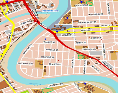
CanMap Streetfiles produced by DMTI, contains detailed street map data for display, analysis and location based applications. The data is tiled and packaged by province. Features included are: street centerline road network, names, address ranges, highway numbers, highway names, road numbers, 6 cartographic road classifications, bridges, tunnels, ferry routes, ice road, 20 000 populated place names, municipal boundaries, and Canada/US border crossings linking Canadian and US Roads. Topographic Area features include: land-use classifications, road network casements, railway and utility features, vegetation, wetlands, physiography, and hydrography. It is recommended to use this with the dataset with Canada Base Map (DMTI).

Metadata
| Title | CanMap Streetfiles |
| Author | DMTI |
| Date | 2006 - 2014, 2001 (see Access row for 2001) |
| Coverage | Canada wide |
| Language | English |
| Format | ESRI Shape {.shp} |
| Projection | Geographic |
| Datum | NAD83 |
| User Agreement | DMTI End User Agreement |
| Documentation | CanMap Streetfiles Product Manual Version 2010.3 contains a detailed description of the data. |
| Access | The 2001 version of the data is available for download at: DMTI Streetfiles 2001 For the most up-to-date (2013) version of the data, members of the McGill Community can obtain copies of the data by filling out the Geospatial Data Request Form. Please indicate the desired provinces or territories. |
| Citation | DMTI Spatial Inc. [computer file] CanMap Streetfiles. Markham: DMTI Spatial Inc., year. |
