Updated: Wed, 10/02/2024 - 13:45

From Saturday, Oct. 5 through Monday, Oct. 7, the Downtown and Macdonald Campuses will be open only to McGill students, employees and essential visitors. Many classes will be held online. Remote work required where possible. See Campus Public Safety website for details.


Du samedi 5 octobre au lundi 7 octobre, le campus du centre-ville et le campus Macdonald ne seront accessibles qu’aux étudiants et aux membres du personnel de l’Université McGill, ainsi qu’aux visiteurs essentiels. De nombreux cours auront lieu en ligne. Le personnel devra travailler à distance, si possible. Voir le site Web de la Direction de la protection et de la prévention pour plus de détails.

Bathymetry of Lake Ontario

Example of Bathymetry of Lake Ontario data

Access

Local CD available at the Walter Hitschfeld Geographic Information Centre Information desk. Call number G3312 O5 C2 2001 N2 CD-ROM

Restrictions

Available to all users.

Coverage

1999. No updates yet.

Description

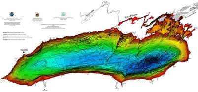
This disc contains several digital data files (both raster and vector) and color graphic images as well as a text discussing the bathymetry and geomorphology of Lake Ontario. The data is available for use in ArGIS and ArcView 3.x, both in vector and raster formats. In addition, ASCII and binary version of the data is available to export into other GIS programs. Images, in EPS, JPEG, and GIF formats, are available.

System Requirements

To view and extract vector and raster data from this CD, you need ArcView 3.x or ArcGIS, available on the public workstations at the Walter Histchfeld Geographic Information Centre, EDRS, and Macdonald Campus Library electronic clasroom.

Producer's Web site

NOAA's National Geophysical Data Center

Questions? Ask us!  Chat • Email • Text • Call            Send feedback    Report a problem

Back to top