Over 260,000 kilometres of river could potentially be severed by planned hydroelectric developments according to McGill University researchers. The Amazon, the Congo, and the Irrawaddy are just a few of the rivers at risk of losing their free-flowing status if the proposed construction of new hydropower dams takes place.

Category:
Published on: 12 Aug 2021

A new study led by researchers from McGill University and INRAE found that between 51-60% of the 64 million kilometres of rivers and streams on Earth that they investigated stop flowing periodically, or run dry for part of the year. It is the first-ever empirically grounded effort to quantify the global distribution of non-perennial rivers and streams.
Category:
Published on: 16 Jun 2021

Two researchers and friends from opposite ends of the Earth have created a world-first high spatial resolution atlas that maps the environmental characteristics of all the globe's rivers and catchments.
HydroATLAS was co-developed by Bernhard Lehner and his team from McGill University’s Department of Geography and Simon Linke from Griffith University’s Australian Rivers Institute.
Category:
Published on: 9 Dec 2019

To what extent are the world’s rivers protected?
In 2010, the Convention on Biological Diversity (CBD), an international treaty for the conservation of biodiversity, set a 17% target for the protection of ‘inland waters,’ including rivers. But there was a problem: there was no good way to measure progress toward that target.
Category:
Published on: 10 Nov 2016

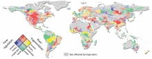
When dams are built they have an impact not only on the flow of water in the river, but also on the people who live downstream and on the surrounding ecosystems. By placing data from close to 6,500 existing large dams on a highly precise map of the world’s rivers, an international team led by McGill University researchers has created a new method to estimate the global impacts of dams on river flow and fragmentation.
Published on: 6 Jan 2015
