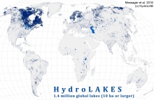
The total shoreline of the world’s lakes is more than four times longer than the global ocean coastline. And if all the water in those lakes were spread over the Earth’s landmass, it would form a layer some four feet (1.3 metres) deep.
Category:
Published on: 15 Dec 2016

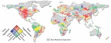
To what extent are the world’s rivers protected?
In 2010, the Convention on Biological Diversity (CBD), an international treaty for the conservation of biodiversity, set a 17% target for the protection of ‘inland waters,’ including rivers. But there was a problem: there was no good way to measure progress toward that target.
Category:
Published on: 10 Nov 2016
When dams are built they have an impact not only on the flow of water in the river, but also on the people who live downstream and on the surrounding ecosystems. By placing data from close to 6,500 existing large dams on a highly precise map of the world’s rivers, an international team led by McGill University researchers has created a new method to estimate the global impacts of dams on river flow and fragmentation.
Published on: 6 Jan 2015

As more people move to urban areas, cities around the world are experiencing increased water stress and looking for additional water supplies to support their continued grow.
Category:
Published on: 3 Jun 2014
