The case study focuses on the coastal communities of Puerto Princesa in Palawan Province, Philippines. This selection is based on the following parameters: first, the community is primarily a low-income(1) informal settlement occupying the coasts of Puerto Princesa Bay, with a large percentage built farther onto the bay; 2) it has a large population with the present number of households close to 3,000; 3) the attempt of the local government to relocate the community was unsuccessful, hence incremental upgrading was implemented. Interventions included the provision of services such as access to water supply and electricity, the provision of communal toilets and the collection of garbage. Despite the availability of these services, sanitation and environmental problems are still prevalent in the community.
This chapter provides a background on the coastal communities of Puerto Princesa. It discusses the communities' context within the city, why they are located on the coasts of Puerto Princesa Bay, the predominant livelihood of the community members, the size of the communities and the general interventions done by the local government to upgrade living conditions. This discussion is followed by a definition of the methodology used for the case study, specifically the tasks involved in the field survey conducted.
4.1 Community Background
a. The City of Puerto Princesa
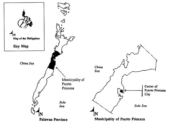
Puerto Princesa City is the capital of Palawan Province. As shown in Figure 4.1, it lies at the midsection of the province which is a long strip of island located at the south west tip of the whole Philippine archipelago. Its land area is 235,264 hectares which is 17% of the total land area of the province.(2)
The city, being relatively the most urbanized area in the whole province, has attracted migrants from other municipalities, as well as from nearby provinces. Studies on population growth show that the population of the city increases by 14 people per day since 1980 due to migration. With Palawan Province having a population of 558,000 persons, approximately 40% of this is concentrated in the city.(3)
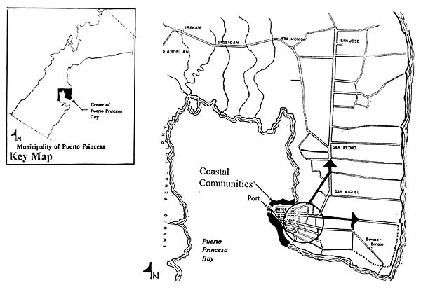
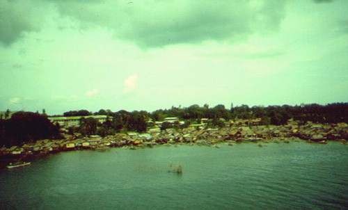
The center of Puerto Princesa City, which is only about 200 square kilometers in area, is bounded by the Puerto Princesa Bay from the northwest to the south perimeter. As illustrated in Figure 4.2, this natural barrier allows the growth of the city to extend only towards the north and east corridors. Thus, the vast coast of the bay adjacent to the city became the ideal site for squatting of the migrating population. The rapid growth of the community resulted in the encroachment of settlements towards the Puerto Princesa Bay as shown in Figure 4.3.
b. Reasons for Occupying the Coasts of Puerto Princesa Bay
A survey conducted by the city government of Puerto Princesa in May 1993 showed that approximately 47% of the total number of households of the coastal communities has been living in the area for more than ten years.(4) An interview with one of the residents who has been living in the area since 1940, indicated that initially the community started as a single layer of houses built along the coastal area. Every year, a new layer develops with the community expanding towards the waters. The rapid growth of the community occurred only in the last thirty years.
The occupation of the coasts of the Puerto Princesa Bay by the community can be attributed to economic reasons as well as to the physical properties of the site. The site, being a coastal reserve zone, was idle. With the site being accessible to both the bay and the city proper, it has been an attractive settlement area for migrants seeking livelihood opportunities from the city as well as from the fishing resources of the bay. The growth of the community was encouraged by the natural properties of the site.
The residents of the coastal communities seek access to the center of the city for employment opportunities, community services and utilities. Within the center of the city, the public market and the nearby slaughterhouse are the major livelihood generating facilities, which attract the people to settle along the coasts. The Puerto Princesa port, which is the main seaport of the whole province is located at the northwestern tip of the city and is adjacent to the city proper. In relation to the coastal communities, the port lies at the middle of the whole stretch of the coastal strip occupied by the community and provides livelihood opportunities to the people.
The municipality of Puerto Princesa is endowed with rich natural resources which boosts the economy of the province. The Puerto Princesa Bay has been identified by the Philippines Bureau of Fisheries and Aquatic Resources (BFAR) as a major fishing ground.(5) The fishing industry is a thriving enterprise in the coastal slums. Migrants who have no fishing experience and who have settled along the coastal communities have resorted to fishing as a means of livelihood. At present, approximately 33.6 % of the community depend on the bay for their fishing livelihood.(6)
The natural properties of the coasts have encouraged the growth of the community. The Puerto Princesa Bay is natural harbor or cove, protected from the rough waters of the Sulu Sea. At the same time, since the province of Palawan has a geographical advantage of not lying in the northwestern typhoon path, tropical storms do not occur in the site. This natural protection has encouraged the community to extend from the coasts towards the bay. Furthermore, the abundance of materials within the site for building houses has influenced the fast growth of the community. Locally available materials such as bamboo, palm leaves, local timber and mangrove are among the predominant construction materials used by the people to build their homes.
c. Community Size
The coastal communities of Puerto Princesa are composed of nine sub-communities or barangays and can be divided into two groups in terms of their location. Barangays Matahimik, Tagumpay, Seaside and Bagong Pag-asa are located at the northern coast of the center of the city. The northern coastal slums comprise 45% of the population of the coastal communities, while Barangays Liwanag, Mabuhay, Pagkakaisa, Bagong Silang and Mandaragat are located at the southwest perimeter of the city. 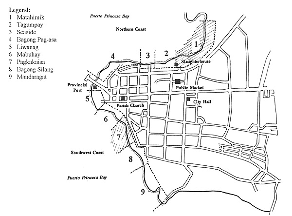 These southwest communities comprise 55% of the total population of the community. Figure 4.4 shows the location of the nine barangays along the bay. The total population of the whole community as of May 1992 has grown to as much as 14,136 persons, corresponding to 2,973 households.(7)
d. Local Government Interventions
The occupation of the coastal sites by the community, which are considered environmentally critical areas, started to concern the local government when the rate of growth of the community increased rapidly. Environmental problems such as pollution of the coasts and the bay are the consequences of allowing the community to invade the area.
Past administrations in the province expressed concern for the problems associated with the coastal communities. Seeing the alarming growth of the community and its consequences, the city government attempted to resettle the community on other sites. Interviews with some local officials and community members indicated that the relocation site was far from the city proper and the means of livelihood to sustain the community were not considered in the planning process. Hence, the people eventually returned to the coastal areas and rebuilt their houses. The failure to relocate the community resulted in on-site incremental improvements provided by the government such as access to water, electricity, the building of communal toilet facilities and the repair and construction of walkways.
The present government is committed to relocate the community by implementing housing projects in different parts of the municipality. The relocation is initiated by the future plans of the city government to construct a coastal boulevard within the area for tourism related activities. To start the process, the city government conducted a survey of the community in May 1992. At the same time, the government established means to control the growth of the community by assigning numbers to each house and not allowing the construction of new houses after.
At present, the government is surveying sites for the various housing projects to accommodate the 2,973 households. A pilot housing project is presently being planned for the first 400 households. In an interview with the city planners, when asked about the time frame of the whole relocation process, no definite period was put forth. With a pilot project housing only 400 households planned in two years, how long will it take to house 2,973 families? With the people living in the coastal areas, facing the same problems in terms of environmental sanitation, for more than twenty years, and with indications that it would still take time for the relocation process to be completed, what could be done to upgrade their sanitation and environmental conditions?
[ TopOfPage(); ]4.2 The Field Survey
The author conducted a field survey in June 1993 and included a study of all the coastal communities of Puerto Princesa as a macro analysis as well as a detailed study of two selected communities, namely Barangay Matahimik and Barangay Pagkakaisa. The survey involved data collection retrieved from the local government as well as non-government organizations working in the communities. The majority of the data analyzed is based on the actual inspection of the communities as well as random interviews of household members.
a. Gathering of General Information on the Coastal Communities
In gathering general information on the coastal communities, the following tasks were done during the field survey: interviews of local government officials and planners regarding the existing conditions of the coastal slums and plans to improve their sanitation conditions; collation of data from the survey conducted by the city government in May 1992;(8) and a preliminary visual survey of the nine communities with photo-documentation. This preliminary survey helped in the selection of the two communities chosen for detailed analysis.
b. Detailed Study of Two Communities
Two of the nine communities, Barangay Matahimik and Barangay Pagkakaisa, were chosen as sub-case studies to analyze in depth the range of sanitation problems in the coastal communities. Barangay Matahimik was chosen for the following reasons: it has the largest population; it is located in the coastal area of the Puerto Princesa Bay with the highest waste concentration; and a large part of the community has been recently rebuilt and upgraded after the occurrence of a fire in March 1991. The last factor makes the community ideal for the analysis since, major interventions were done by the local government after the fire. Barangay Pagkakaisa, was selected for the following reasons: it is the most congested and it has the worst living conditions among the nine communities; it is located on the other side of the city, which is at the opposite side of Barangay Matahimik, where conditions are different; and finally, like Barangay Matahimik, it has also been affected by a fire, hence major upgrading was done to the community.
c. Random Household Interviews
For both communities, random household interviews were conducted. Due to time constraints, a quota of only 5% of the total number of households of the community was set. Thus, 26 households were interviewed for Barangay Matahimik, which has 493 households and 17 for Barangay Pagkakaisa which has 297 households. The reliance of the data gathered are geared more towards qualitative analysis rather than quantitative. The data gathered are used for exploratory and descriptive analysis of the existing conditions within the communities. Additional information not gathered from the interviews are based on the author's observations and insights.
The basis of household interviews are discussed as follows. The location of the house and the availability or cooperation of the household members influenced the selection of households for interviews. Household conditions can be classified according to their location within the coastal areas. This includes those houses which are built on the elevated areas which are not reached by the tide, houses built on the tidal mudflats which are dry during low tide and are inundated during the high tide, and those built on the waters. For every walkway, at least one household from each location was chosen for interview. The availability and cooperation of the household members to be interviewed also influenced the household selection. Interviews were conducted from 10:00 a.m. to 6:00 p.m. Since most of the men were at work during these hours, the interviewees were mostly housewives. This is an advantage for the study since the housewives interviewed appeared more familiar with the conditions of their homes.
The manner of interview was done through informal conversations with the household members. The concerns of the interviews that are essential to the thesis include: utilities and services available to the household; cultural and social factors affecting sanitary and hygienic practices, health conditions of the household members and conditions of the house. Utilities and services available to the household include water supply, the type of toilet and means of waste disposal, bathing, washing and laundry facilities and the garbage disposal method. 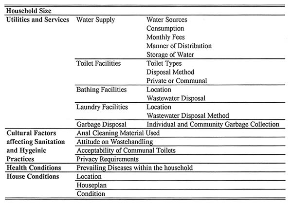 Cultural and social factors affecting sanitary and hygienic practices include the anal cleaning material used, the attitude on wastehandling, acceptability of communal toilet and privacy requirements. Health conditions of the household members refers to observed prevailing sicknesses among family members. Table 4.1 enumerates these considerations.
Results of the interviews were documented and preliminary sketches of the houses were made at the end of the day. To structure the results of the interviews, a Respondent Profile Form, shown in Plate 2, Appendix B was filled out. In this form, other information not gathered from the interview was based on the results of the survey conducted by the city government. The summary of household interviews for both communities are tabulated in Plates 3 and 4, Appendix B. The results of the survey and the analysis of data gathered are presented in the succeeding chapters.
[ TopOfPage(); ]1. A survey of the monthly income of the coastal communities shows that approximately 68.19% of the households earn not more than $181.82 (Canada.) per month, with the majority earning only between $91 to $136 (Canada), which is below the national poverty level of Philippines. City of Puerto Princesa Survey, May 1992. See Appendix A, Table 2: Household Monthly Income.
2. City Profile of Puerto Princesa, Palawan, Philippines, Government Document, 1989.
4. See Appendix A, Table 1 : Household Mobility Indicators of the coastal communities, Puerto Princesa City Survey, May 1992.
5. Palawan Integrated Area Development Project (PIADP) Study, (Unpublished Report), 1989.
6. See Appendix A, Table 3: Number of Households Dependent on Fishing Livelihood, Coastal Communities, Puerto Princesa City Survey, May 1992.
7. See Appendix A, Table 4: Population per Barangay. Puerto Princesa City Survey, 1992.
8. This survey was conducted by the local government of Puerto Princesa to support future plans for relocation and low-cost housing project for the coastal communities.
[ TopOfPage(); ]